With the right funding and back ground I would have been
killed many years ago, on a reckless and ill thought out expedition up K2 in my
pants wearing a fruit bowl hat and cowboy boots. Fortunately or not depending
on your viewpoint, my back ground and funding never allowed such frivolous
risks to life and limb, and in all fairness as a child in the seventies with
asthma, I spent a lot of the time (allegedly) at deaths door.
I remember things slightly differently, I remember playing
out on my bike, falling off now banned school climbing frames, and jumping
between roofs of adjacent garage blocks on a green that had been created
because a V2 landed there one night and destroyed or damaged more than seventy
houses (and nearly killed my dad whose ceiling fell on him two streets away). I
remember running about over what had once been a municipal dump in a corner of
Newham now occupied by Newham General Hospital. It was an L shape of land that
had a central dirt track running through it, and various branches running off
it. It was a mixture of grass and scrub, blackberries, Elders, Japanese Knotweed
and Nettles (there were no tall trees). South of this was the old A13 dual
carriageway (now a four lane artery that pumps vehicular life into the new city
of Docklands and to a lesser extent the old City of London). In those days
there were enough gaps between cars that you could run across the A13 in two
well timed hops (today you would be killed by lane two). The south side of the
A13 was a vast expanse of marsh, derelict fallen downs, part filled in craters
from repeated German bombing raids. The
occasional Pillbox subsided into the soft ground. An old style and early
container yard (the type that saw an end to the Royal Docks and its sorting
warehouses ), and literally hundreds upon hundreds of open acres of not a lot
... I forgot the stinking abattoir, Zif Meats where you could find the horns of
cows, hollowed and gnawed by the lord gods many detritivors from rats down the
chain.
Heading east you could be on open ground with the odd fallen
or trampled down fence from days of yore until you arrived at the banks of the
Thames at what is now Galleons Reach Outlet shopping thing. You could wander
among the giant fallen in and derelict monoliths of the old Beckton Gasworks http://en.wikipedia.org/wiki/Beckton_gasworks
(for those who would like to see the place today, watch Full Metal Jacket, the
city scenes were shot in my once playground).
http://en.wikipedia.org/wiki/Beckton_gasworks).
I also found out reading this article to check my facts that other parts of
Vietnam were filmed at Cliffe in Kent, a short hop over the river from Tilbury
and a place we used to SCUBA dive in (without permission), in the old abandoned
quarries there.
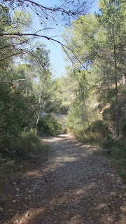
 |
| The Brown Bit is the Path |
Heading south from the A13 you could walk as far as the old
London Royal Docks (now London City Airport), and if you were willing to detour
round the docks, you could find yourself in North Woolwich, where you could
take the foot tunnel or Ferry to the other side of the river (though I digress
here a little). Going east through North Woolwich you would eventually arrive
at the southern extent of the area left derelict after the Second World War,
specifically the flattened remains of Harland and Wolff’s shipyard, builders of
HMS Belfast and the Titanic,(though not on the Thames), the shipyard was
demolished in the sixties having been run down, not bombed by Herr Hitler) http://en.wikipedia.org/wiki/Harland_and_Wolff.
That open area then rolled north to meet the Beckton Gas Works mentioned above.
 |
| Towards the Sea |
 |
| Towards Fangorn ... We Think |
What you ask has all this to do with Mountains, fruit bowl
hats and cowboy boots, and being killed with the right funding?
 |
| The Vikings are Coming |
The answer is nothing and everything.
 |
| Wilderness Photobomb |
Yesterday, we went for a walk, we’ve been in Alcossebre for
seven days. We wanted to stop and clear the new year before we moved on again,
to let things get back to normal (though we have discovered that the 5
th
and 6
th January are possible Bank Holidays in Spain, and that they
are the equivalent of our December 25
th from a childs perspective).
 |
| Another Peaky Bit |
We’ve walked the rugged coast here on and off for five days,
first from a campsite called Playa Tropicana which wasn’t our cup of tea. It
was naff in the extreme, jammed full of little Englanders doing winter Ex-pat
things, coffee mornings, sitting around watching telly ... they even had a
committee and an agenda for some bullshit, and the site itself was sardine
tight with a Roman statue theme (frankly I hated it). We did our two nights and
then moved to our current base` Camping Ribimar’, just north of Alcossebre down
a dirt track (Moho Moho has done some off-road).
 |
| A Long Walk Back Down |
We’re in woods off an unmade road that runs from Alcossebre
to Peniscola (Penis Cola tee hee hee) for
15 kilometres. The coast itself is a mix of tiny beaches as little as
three or four metres wide; some sandy, others pebbles; from the size of a
marble to the size of a football, and every size in-between. There are shelves and
layers of different rocks, waiting for
erosion and gravity to do their worst and collapsed sea caves.
 |
| Doesn't Really Capture the Drop After the Treeline |
Inland a few hundred metres the land starts to rise to a
height around 550 metres. We scrambled and yomped 520 of those metres, through valleys, then gorges
and then ravines, upwards and eventually out onto a goat or donkey track made
some time before dynamite blew out a road some miles south. By the way, as we
are told Eskimos have lots of name for snow, or correctly types of snow, so the
Spanish have lots of names for their high landscape; far more than I can
explain. However someone has and here’s the link: http://www.iberianature.com/material/mountainssynonyms.html
 |
| See Just leads You On |
 |
| Just a Wafer Thin Scramble |
 |
A Wide Bit with Sky
These various gullies have all been cut by the passage of
torrents of water, evidenced here and there by bare rocks scoured smooth, while
others higher up have been dry long enough for other slower erosive forces to
rough up the sheen left by the earlier running water. In wide cracks or cracks
made wide, Pine trees grow at impossible
angles, Date Palms likewise cling to places you wouldn’t expect. The Palms
stunted (I think due to a lack of light), here and there Ivy grows as does Blackberry
and creepers I know not the names of,
this gives the whole place a very strange atmosphere, silent for the most
part, very still and dry, and yet jungle-like and prehistoric (there are a lot
of wows along that track). The trees are wild grown and straight, but very thin,
and not too tall outside of the deep places where it can be cold despite the
broken sun shining through.
|
As with the drive across the high plateau, I periodically
looked at the barometer readings on my watch, and at our highest point air
pressure had dropped from 1014 millibars at sea level to 968 millibars at 520
metres above sea level. I also took altitude readings from the same watch, my
now trusted Casio Protrek Triple Sensor Tough Solar Titanium (£350 from
Watchshop.com ... other retailers are available etc).
We were three hours walking in to our highest point and
nearly three hours walking back out. And now maybe we see why fruit bowl hats
and cowboy boots get a mention.
In truth we weren’t
as well prepared for this hike as we should have been. We didn’t take enough
water and we didn’t take lunch, however in mitigation we had intended only to
go as far as the first incline up to see the lay of the land for today when we planned to walk up. And let this be a lesson, them there high
mysterious places lead you on, a minor foray with binoculars to see the lay of
the land turned into a six hour hike with a litre and a half of water and no
food, no torch, no silver blankets (in case of issues), no rope or para cord,
and finally no first aid kit ... we were a tinsy bit irresponsible.
The pictures will
fill in the blanks of my description.
As a child I couldn’t aspire to climb mountains, we didn’t
have TV until I was probably eight years old, I had no dreams to aim for. But
what I did have was the remains of a part of East London, used as a tip, bombed
flat during the Blitz or left polluted by the process that turns coal into coal
gas. A vast brown and green waste and wetland, a place where as a child and
early teenager I would disappear into further and further, year after year with
barely a breakfast in me, no water in a bottle and no real awareness of the
risks. And that’s what happened on new years’ day; there was a wilderness,
there is a wilderness, and in many ways so much more dangerous than the one I
wandered as a child, but we lived to tell the tale despite being irresponsible,
and I’m so glad we went up that hill.


No comments:
Post a Comment